A DOQQ or Digital Orthographic Quarter-Quad is simply a digitized aerial photo map that has been rectified of any errors so that they show their true geographic location. The DOQQ above was one taken of a heavily populated section of London.
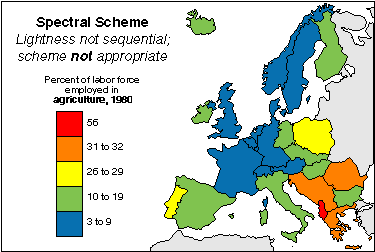
A univariate choropleth map is a choropleth map that only displays one variable. The univariate map above shows the percent of the labor force in different countries in Europe that is employed in agriculture. This is the only theme or focus of the map which classifies it as a univariate choropleth.
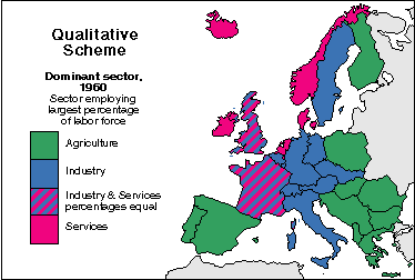
A nominal area choropleth map shows non-quantitative data. Since the data that is being mapped out is nominal it can not be put in any sort of numerical order so the colors chosen to represent the data are not different shades of the same color, as in most choropleth maps, but rather colors that are clearly distinct from each other. The map above shows the sectors that employ the largest percent of the labor force of areas in Europe.
Cartographic animation is used by meteorologists to portray weather patterns in an informative and visual way. This type of map layers a three dimensional layer of weather on to of a two dimensional map and the weather patterns are usually in motion.
A classed choropleth map is one that is directed towards determining the classification of a choropleth map. Essentially, this means figuring out the different classes of what is being measured in the map, and how to shade the map to display these classifications. There is also a legend to help the reader better understand these classifications.
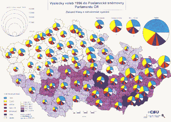
A continuously variable circle map is very similar to a normal circle map, except for the fact that in addition to the variable represented by the actual circle, another variable is represented inside of each of the circles. In this map, the bigger circles represent larger populations, and inside the circle, the variation of the population is represented in the form of a pie chart.
A similarity matrix simply shows the similarity between data values. It is for this reason that a similarity matrix and a correlation matrix are different. Data values that are more similar receive higher scores, and data values less similar receive lower scores.